Difference between revisions of "S-122"
(A collation of all things Marine Protected Area (MPA)) |
|||
| Line 2: | Line 2: | ||
<br>''a place to discuss and follow the work'' | <br>''a place to discuss and follow the work'' | ||
| + | ==Feature Concept Dictionary Terms== | ||
| − | == Sample Data == | + | {| class="wikitable sortable" |
| + | |- | ||
| + | ! Code !! Description !! Category | ||
| + | |- | ||
| + | | [[MPAARE]] || <span style="color:black;">Marine Protected Area</span> || geographic feature | ||
| + | |- | ||
| + | | [[MPADET]] || Marine Protected Area details || deleted | ||
| + | |- | ||
| + | | [[mpapen]] || Marine Protected Area Penalty || deleted - see [[Talk:Mpapen]] | ||
| + | |- | ||
| + | |} | ||
| + | |||
| + | |||
| + | == Sample/Test Data == | ||
[http://wp12183585.server-he.de/npubwiki/wiki/index.php/SNPWG6#S-122_Marine_Protected_Area Test data wiki page] | [http://wp12183585.server-he.de/npubwiki/wiki/index.php/SNPWG6#S-122_Marine_Protected_Area Test data wiki page] | ||
| + | |||
| + | NARW test data sample from the test data wiki page is shown below as an inline example for comments within the wiki. | ||
| + | |||
| + | ===Presence of the North Atlantic Right Whales=== | ||
| + | The North Atlantic right whale is one of the world's most endangered large whale species. North Atlantic right whales are found primarily in continental shelf waters between Florida and Nova Scotia. They migrate annually along the east coast between the feeding grounds off New England and Canada and the calving grounds off Florida, Georgia and South Carolina. Because right whales mate, rest, feed and nurse their young at the surface, and often do not move out of the way of oncoming ships, they are highly vulnerable to being struck. Pregnant females and females with nursing calves appear to be particularly vulnerable to collisions with ships. Ship strikes and fishing gear entanglements are the two known sources of human-related mortality. Intentionally approaching within 500 yards of right whales is prohibited and is a violation of federal law. (See 50 CFR 224.103, chapter 2 for limits, regulations and exceptions.) | ||
| + | |||
| + | ===Description=== | ||
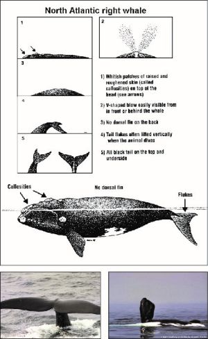
| + | [[File:NARW-fig1.jpg|thumb|right|Fig. a - North Atlantic Right Whale Description]] Right whales are large baleen whales (Fig. a). Adults are generally 45 to 55 feet in length and can weigh up to 70 tons. The body is mostly black, but irregularly shaped white patches may be present on the ventral surface. The best field identification marks are a broad back with no dorsal fin, irregular bumpy white patches (callosities) on the head, and a distinctive two-column V-shaped blow when viewed from directly behind or in front of the whale. The whales have broad, paddle-shaped flippers and a broad, deeply notched tail. (See following diagrams and photographs.) Right whales are slow moving and seldom travel faster than 5 or 6 knots. They can stay submerged for 10 to 20 minutes and may appear suddenly when surfacing to breathe. They are often seen alone or in small groups. At times, right whales form large courtship groups of 20 to 30 animals. | ||
| + | |||
| + | ===Seasonal Occurance=== | ||
| + | During seasons and in areas where right whales may occur, vessel operators should maintain a sharp lookout for whales and reduce speeds when consistent with safe navigation. In any given year oceanographic variability may affect the seasonal distribution of right whales. In 1986, right whales were frequently sighted within the Stellwagen Bank National Marine Sanctuary throughout the summer, and in the early spring of 1998 a large number of right whales were documented near the Narragansett/Buzzards Bay Traffic Separation Scheme. Three areas in U.S. waters have been designated as critical habitats for North Atlantic right whales. The northern critical habitats, the Great South Channel (east of Cape Cod) and Cape Cod Bay extending into Massachusetts Bay, are feeding and nursery grounds. The southern critical habitat, off coastal Florida and Georgia (Sebastian Inlet, Florida to the Altamaha River, Georgia), is a calving area. (See 50 CFR 226.203, chapter 2 for limits, regulations and exceptions). | ||
| + | |||
| + | Seasonal occurrence of North Atlantic right whales | ||
| + | {| class="wikitable sortable" | ||
| + | |- | ||
| + | ! Location !! Season !! Comments | ||
| + | |- | ||
| + | | Central Gulf of Maine (Jordan Basin, Cashes Ledge) || April-June<br>October -December || Editorial: <br>Most of the population can be found in this area during this time | ||
| + | |- | ||
| + | | Cape Cod Bay|| December-May|| Editorial: <br>Most of the population can be found in this area during this time | ||
| + | |- | ||
| + | | Great South Channel, northern edge of Georges Bank || March-July || Editorial:<br>Most of the population can be found in this area during this time | ||
| + | |- | ||
| + | | Bay of Fundy, Scotian Shelf (Browns Bank, Roseway Basin)|| July-October ||Most of the population can be found in this area during this time | ||
| + | |- | ||
| + | | Jeffreys Ledge|| October-December ||Whales are frequently sighted in this area | ||
| + | |- | ||
| + | | Stellwagen Bank National Marine Sanctuary|| Year-round ||Peak sightings occur in the early spring with infrequent sightings in the summer | ||
| + | |- | ||
| + | | New York to North Carolina|| November-April ||The migration corridor between right whale habitats is within 30 miles of the Atlantic coast | ||
| + | |- | ||
| + | | South Carolina, Georgia and Florida calving area|| November-April ||Calving right whales have been sighted as far north as Cape Fear, NC and as far south as Miami, FL with rare sightings in the Gulf of Mexico | ||
| + | |- | ||
| + | |} | ||
| + | |||
| + | |||
| + | |||
| + | ===Speed restrictions=== | ||
| + | ''to protect North Atlantic Right Whales'' | ||
| + | ====224.105==== | ||
| + | <ol type='a'> | ||
| + | <li>The following restrictions apply to: All vessels greater than or equal to 65 ft (19.8 m) in overall length and subject to the jurisdiction of the United States, and all other vessels greater than or equal to 65 ft (19.8 m) in overall length entering or departing a port or place subject to the jurisdiction of the United States. These restrictions shall not apply to U.S. vessels owned or operated by, or under contract to, the Federal Government. This exemption extends to foreign sovereign vessels when they are engaging in joint exercises with the U.S. Department of the Navy. In addition, these restrictions do not apply to law enforcement vessels of a State, or political subdivision thereof, when engaged in law enforcement or search and rescue duties. | ||
| + | |||
| + | <ol> | ||
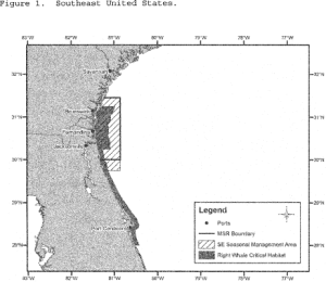
| + | <li>Southeast U.S. (south of St. Augustine, FL to north of Brunswick, GA): Vessels shall travel at a speed of 10 knots or less over ground during the period of November 15 to April 15 each year in the area bounded by the following: Beginning at 31°27'00.0"N, 80°51'36.0"W; thence west to charted mean high water line then south along charted mean high water line and inshore limits of COLREGS limit to a latitude of 29°45'00.0"N thence east to 29°45'00.0"N, 80°51'36.0"W; thence back to starting point. (Fig. 1). [[File:Fig-1.png|thumb|right|Fig. 1 - Southeast Right Whale area]] | ||
| + | </li> | ||
| + | <li>Mid-Atlantic U.S. (from north of Brunswick, Georgia to Rhode Island): Vessels shall travel 10 knots or less over ground in the period November 1 to April 30 each year: | ||
| + | <ol type="i"> | ||
| + | <li>In the area bounded by the following: 33°56'42.0"N, 77°31'30.0"W; thence along a NW bearing of 313.26° True to charted mean high water line then south along mean high water line and inshore limits of COLREGS limit to a latitude of 31°27'00.0"N; thence east to 31°27'00.0"N, 80°51'36.0"W; thence to 31°50'00.0"N, 80°33'12.0"W; thence to 32°59'06.0"N, 78°50'18.0"W; thence to 33°28'24.0"N, 78°32'30.0"W; thence to 33°36'30.0"N, 77°47'06.0"W; thence back to starting point.;</li> | ||
| + | <li>Within a 20-nm (37 km) radius (as measured seaward from COLREGS delineated coast lines and the center point of the port entrance) (Fig. 2) at the | ||
| + | <ol type="A"> | ||
| + | <li>Ports of New York/New Jersey: 40°29'42.2"N, 73°55'57.6"W;</li> | ||
| + | <li>Delaware Bay (Ports of Philadelphia and Wilmington): 38°52'27.4"N, 75°01'32.1"W;</li> | ||
| + | <li>Entrance to the Chesapeake Bay (Ports of Hampton Roads and Baltimore): 37°00'36.9"N, 75°57'50.5"W; and</li> | ||
| + | <li>Ports of Morehead City and Beaufort, NC: 34°41'32.0"N, 76°40'08.3"W; and</li> | ||
| + | </ol></li> | ||
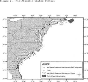
| + | <li>In Block Island Sound, in the area bounded by the following coordinates: Beginning at 40°51'53.7"N, 70°36'44.9"W; thence to 41°20'14.1"N, 70°49'44.1"W; thence to 41°04'16.7"N, 71°51'21.0"W; thence to 40°35'56.5"N, 71°38'25.1"W; thence back to starting point. (Fig. 2).[[File:Fig-2.png|thumb|right|Fig. 2 - Mid-Atlantic Right Whale area]]</li> | ||
| + | </ol></li> | ||
| + | <li>Northeast U.S. (north of Rhode Island): | ||
| + | <ol type="i"> | ||
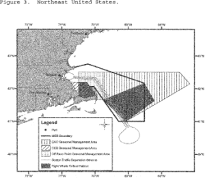
| + | <li>In Cape Cod Bay, MA: Vessels shall travel at a speed of 10 knots or less over ground during the period of January 1 to May 15 in Cape Cod Bay, in an area beginning at 42°04'56.5"N, 70°12'00.0"W; thence north to 42°12'00.0"N, 70°12'00.0"W; thence due west to charted mean high water line; thence along charted mean high water within Cape Cod Bay back to beginning point. (Fig. 3). [[File:Fig-3.png|thumb|right|Fig. 3 - Northeast Right Whale area]]</li> | ||
| + | <li>Off Race Point: Vessels shall travel at a speed of 10 knots or less over ground during the period of March 1 to April 30 each year in waters bounded by straight lines connecting the following points in the order stated (Fig. 3): 42°30'00.0"N, 69°45'00.0"W; thence to 42°30'00.0"N, 70°30'00.0"W; thence to 42°12'00.0"N, 70°30'00.0"W; thence to 42°12'00.0"N, 70°12'00.0"W; thence to 42°04'56.5"N, 70°12'00.0"W; thence along charted mean high water line and inshore limits of COLREGS limit to a latitude of 41°40'00.0"N; thence due east to 41°41'00.0"N, 69°45'00.0"W; thence back to starting point.</li> | ||
| + | <li>Great South Channel: Vessels shall travel at a speed of 10 knots or less over ground during the period of April 1 to July 31 each year in all waters bounded by straight lines connecting the following points in the order stated (Fig. 3): | ||
| + | |||
| + | <br>42°30'00.0"N, 69°45'00.0"W | ||
| + | <br>41°40'00.0"N, 69°45'00.0"W | ||
| + | <br>41°00'00.0"N, 69°05'00.0"W | ||
| + | <br>42°09'00.0"N, 67°08'24.0"W | ||
| + | <br>42°30'00.0"N, 67°27'00.0"W | ||
| + | <br>42°30'00.0"N, 69°45'00.0"W</li> | ||
| + | </ol></li> | ||
| + | </ol> | ||
| + | </li> | ||
| + | |||
| + | <li>Except as noted in paragraph (c) of this section, it is unlawful under this section: | ||
| + | <ol type="1"> | ||
| + | <li>For any vessel subject to the jurisdiction of the United States to violate any speed restriction established in paragraph (a) of this section; or</li> | ||
| + | <li>For any vessel entering or departing a port or place under the jurisdiction of the United States to violate any speed restriction established in paragraph | ||
| + | (a) of this section.</li> | ||
| + | </ol> | ||
| + | </li> | ||
| + | |||
| + | <li>A vessel may operate at a speed necessary to maintain safe maneuvering speed instead of the required ten knots only if justified because the vessel is in an area where oceanographic, hydrographic and/or meteorological conditions severely restrict the maneuverability of the vessel and the need to operate at such speed is confirmed by the pilot on board or, when a vessel is not carrying a pilot, the master of the vessel. If a deviation from the ten-knot speed limit is necessary, the reasons for the deviation, the speed at which the vessel is operated, the latitude and longitude of the area, and the time and duration of such deviation shall be entered into the logbook of the vessel. The master of the vessel shall attest to the accuracy of the logbook entry by signing and dating it.</li> | ||
| + | |||
| + | <li>This final rule expires on December 9, 2013.</li> | ||
| + | </ol> | ||
| + | |||
| + | ====Mandatory Speed Restrictions==== | ||
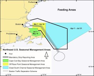
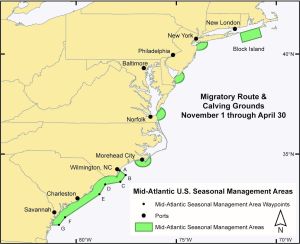
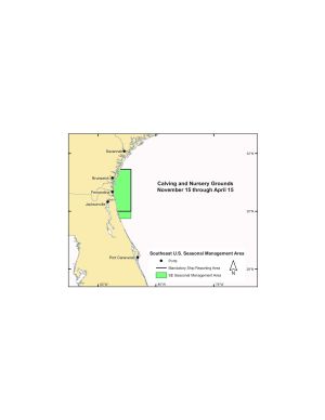
| + | [[File:NE-managementArea.jpg|thumb|right|Fig. b - Northeast Management area]] [[File:Mid-Atlantic-managementArea.jpg|thumb|right|Fig. c - MidAtlantic Management area]] [[File:SE-managementArea.jpg|thumb|right|Fig. d - Southeast Management area]] Vessels 65 feet or greater in length overall (L.O.A.) are subject to mandatory speed restrictions of 10 knots or less in seasonal management areas (SMA) along the U.S. East Coast during times when right whales are likely to be present (See following maps for locations of SMAs). The Northeastern SMA speed restrictions are in place from January 1 through May 15 in Cape Cod Bay, from March 1 through April 30 off Race Point, and from April 1 through July 31 in the Great South Channel. Speed restrictions in the Mid-Atlantic U.S. SMAs are in place from November 1 to April 30 and include Block Island Sound, entry into the Ports of New York/New Jersey, Delaware Bay, Entrance to Chesapeake Bay, and the Ports of Morehead City and Beaufort, NC, and within a continuous boundary approximately 20 nautical miles from shore around the major ports of Wilmington, NC, Charleston, SC and Savannah, GA. Speed restrictions are in place in the Southeastern U.S. SMA from November 15 to April 15; this area extends from shore approximately 30 nautical miles eastward and contains the major ports of Brunswick, GA, Fernandina Beach, FL and Jacksonville, FL. (See 50 CFR 224.105, chapter 2 for regulations, limitations, and exceptions and complete description of the SMAs.) NOAA Fisheries may also establish voluntary Dynamic Management Areas (DMAs) when right whales are present in areas and times not covered by the SMAs. Information about established DMAs will be announced over NOAA's customary maritime communication media. Mariners are encouraged to avoid or reduce speeds to 10 knots or less while transiting through DMAs. | ||
| + | |||
| + | |||
| + | ===Precautions=== | ||
| + | ''Precautions when transiting right whale habitat and areas of recently reported right whale sightings:'' | ||
| + | |||
| + | NOAA recommends the following precautionary measures be taken to avoid adverse interactions with North Atlantic right whales: | ||
| + | |||
| + | Before entering right whale habitat, check Coast Guard Broadcast Notices to Mariners, NAVTEX, NOAA Weather Radio, Mandatory Ship Reporting (MSR) system, Cape Cod Canal Vessel Traffic Control, the Bay of Fundy Vessel Traffic Control, as well as other sources for recent right whale sighting reports. Local ship pilots also have information on whale sightings and safe local operating procedures. | ||
| + | |||
| + | Review right whale identification materials and maintain a sharp watch with lookouts familiar with spotting whales. Although right whales are large, their dark color and lack of a dorsal fin can make them difficult to spot. | ||
| + | |||
| + | Avoid transiting through the right whale habitats and areas where right whales have recently been sighted. If transiting between ports within critical habitats, minimize transit distance. Route around observed or recently reported right whales and anticipate delays due to prudent seamanship in response to whale sightings. Avoid transits at night or during periods of low visibility. | ||
| + | |||
| + | If a right whale is sighted from the ship or reported along the intended track of the ship, mariners should exercise caution, post a lookout and reduce speed to 10 knots when consistent with safe navigation. If a right whale is sighted, a vessel must steer a course away from the right whale and immediately leave the area at slow safe speed. Do not assume right whales will move out of the way of an approaching vessel. Mariners should keep in mind that it is illegal to approach a right whale closer than 500 yards. | ||
| + | |||
| + | ===Reporting=== | ||
| + | Reporting details in case of whale struck: | ||
| + | |||
| + | In the event of a strike or sighting of a dead, injured or entangled whale, the following information should be provided: | ||
| + | |||
| + | *location, date, and time of the accident or sighting of a carcass or an entangled whale, | ||
| + | *speed and course of the vessel, | ||
| + | *vessel specifications such as size and propulsion, | ||
| + | *water depth, | ||
| + | *environmental conditions such as visibility, wind speed and direction, | ||
| + | *description of the impact, | ||
| + | *fate of the animal, and | ||
| + | *species and size, if known. | ||
| + | |||
| + | |||
| + | ==Issues== | ||
Revision as of 04:48, 8 December 2015
Marine Protected Areas
a place to discuss and follow the work
Feature Concept Dictionary Terms
| Code | Description | Category |
|---|---|---|
| MPAARE | Marine Protected Area | geographic feature |
| MPADET | Marine Protected Area details | deleted |
| mpapen | Marine Protected Area Penalty | deleted - see Talk:Mpapen |
Sample/Test Data
NARW test data sample from the test data wiki page is shown below as an inline example for comments within the wiki.
Presence of the North Atlantic Right Whales
The North Atlantic right whale is one of the world's most endangered large whale species. North Atlantic right whales are found primarily in continental shelf waters between Florida and Nova Scotia. They migrate annually along the east coast between the feeding grounds off New England and Canada and the calving grounds off Florida, Georgia and South Carolina. Because right whales mate, rest, feed and nurse their young at the surface, and often do not move out of the way of oncoming ships, they are highly vulnerable to being struck. Pregnant females and females with nursing calves appear to be particularly vulnerable to collisions with ships. Ship strikes and fishing gear entanglements are the two known sources of human-related mortality. Intentionally approaching within 500 yards of right whales is prohibited and is a violation of federal law. (See 50 CFR 224.103, chapter 2 for limits, regulations and exceptions.)
Description
Right whales are large baleen whales (Fig. a). Adults are generally 45 to 55 feet in length and can weigh up to 70 tons. The body is mostly black, but irregularly shaped white patches may be present on the ventral surface. The best field identification marks are a broad back with no dorsal fin, irregular bumpy white patches (callosities) on the head, and a distinctive two-column V-shaped blow when viewed from directly behind or in front of the whale. The whales have broad, paddle-shaped flippers and a broad, deeply notched tail. (See following diagrams and photographs.) Right whales are slow moving and seldom travel faster than 5 or 6 knots. They can stay submerged for 10 to 20 minutes and may appear suddenly when surfacing to breathe. They are often seen alone or in small groups. At times, right whales form large courtship groups of 20 to 30 animals.
Seasonal Occurance
During seasons and in areas where right whales may occur, vessel operators should maintain a sharp lookout for whales and reduce speeds when consistent with safe navigation. In any given year oceanographic variability may affect the seasonal distribution of right whales. In 1986, right whales were frequently sighted within the Stellwagen Bank National Marine Sanctuary throughout the summer, and in the early spring of 1998 a large number of right whales were documented near the Narragansett/Buzzards Bay Traffic Separation Scheme. Three areas in U.S. waters have been designated as critical habitats for North Atlantic right whales. The northern critical habitats, the Great South Channel (east of Cape Cod) and Cape Cod Bay extending into Massachusetts Bay, are feeding and nursery grounds. The southern critical habitat, off coastal Florida and Georgia (Sebastian Inlet, Florida to the Altamaha River, Georgia), is a calving area. (See 50 CFR 226.203, chapter 2 for limits, regulations and exceptions).
Seasonal occurrence of North Atlantic right whales
| Location | Season | Comments |
|---|---|---|
| Central Gulf of Maine (Jordan Basin, Cashes Ledge) | April-June October -December |
Editorial: Most of the population can be found in this area during this time |
| Cape Cod Bay | December-May | Editorial: Most of the population can be found in this area during this time |
| Great South Channel, northern edge of Georges Bank | March-July | Editorial: Most of the population can be found in this area during this time |
| Bay of Fundy, Scotian Shelf (Browns Bank, Roseway Basin) | July-October | Most of the population can be found in this area during this time |
| Jeffreys Ledge | October-December | Whales are frequently sighted in this area |
| Stellwagen Bank National Marine Sanctuary | Year-round | Peak sightings occur in the early spring with infrequent sightings in the summer |
| New York to North Carolina | November-April | The migration corridor between right whale habitats is within 30 miles of the Atlantic coast |
| South Carolina, Georgia and Florida calving area | November-April | Calving right whales have been sighted as far north as Cape Fear, NC and as far south as Miami, FL with rare sightings in the Gulf of Mexico |
Speed restrictions
to protect North Atlantic Right Whales
224.105
- The following restrictions apply to: All vessels greater than or equal to 65 ft (19.8 m) in overall length and subject to the jurisdiction of the United States, and all other vessels greater than or equal to 65 ft (19.8 m) in overall length entering or departing a port or place subject to the jurisdiction of the United States. These restrictions shall not apply to U.S. vessels owned or operated by, or under contract to, the Federal Government. This exemption extends to foreign sovereign vessels when they are engaging in joint exercises with the U.S. Department of the Navy. In addition, these restrictions do not apply to law enforcement vessels of a State, or political subdivision thereof, when engaged in law enforcement or search and rescue duties.
- Southeast U.S. (south of St. Augustine, FL to north of Brunswick, GA): Vessels shall travel at a speed of 10 knots or less over ground during the period of November 15 to April 15 each year in the area bounded by the following: Beginning at 31°27'00.0"N, 80°51'36.0"W; thence west to charted mean high water line then south along charted mean high water line and inshore limits of COLREGS limit to a latitude of 29°45'00.0"N thence east to 29°45'00.0"N, 80°51'36.0"W; thence back to starting point. (Fig. 1).
- Mid-Atlantic U.S. (from north of Brunswick, Georgia to Rhode Island): Vessels shall travel 10 knots or less over ground in the period November 1 to April 30 each year:
- In the area bounded by the following: 33°56'42.0"N, 77°31'30.0"W; thence along a NW bearing of 313.26° True to charted mean high water line then south along mean high water line and inshore limits of COLREGS limit to a latitude of 31°27'00.0"N; thence east to 31°27'00.0"N, 80°51'36.0"W; thence to 31°50'00.0"N, 80°33'12.0"W; thence to 32°59'06.0"N, 78°50'18.0"W; thence to 33°28'24.0"N, 78°32'30.0"W; thence to 33°36'30.0"N, 77°47'06.0"W; thence back to starting point.;
- Within a 20-nm (37 km) radius (as measured seaward from COLREGS delineated coast lines and the center point of the port entrance) (Fig. 2) at the
- Ports of New York/New Jersey: 40°29'42.2"N, 73°55'57.6"W;
- Delaware Bay (Ports of Philadelphia and Wilmington): 38°52'27.4"N, 75°01'32.1"W;
- Entrance to the Chesapeake Bay (Ports of Hampton Roads and Baltimore): 37°00'36.9"N, 75°57'50.5"W; and
- Ports of Morehead City and Beaufort, NC: 34°41'32.0"N, 76°40'08.3"W; and
- In Block Island Sound, in the area bounded by the following coordinates: Beginning at 40°51'53.7"N, 70°36'44.9"W; thence to 41°20'14.1"N, 70°49'44.1"W; thence to 41°04'16.7"N, 71°51'21.0"W; thence to 40°35'56.5"N, 71°38'25.1"W; thence back to starting point. (Fig. 2).
- Northeast U.S. (north of Rhode Island):
- In Cape Cod Bay, MA: Vessels shall travel at a speed of 10 knots or less over ground during the period of January 1 to May 15 in Cape Cod Bay, in an area beginning at 42°04'56.5"N, 70°12'00.0"W; thence north to 42°12'00.0"N, 70°12'00.0"W; thence due west to charted mean high water line; thence along charted mean high water within Cape Cod Bay back to beginning point. (Fig. 3).
- Off Race Point: Vessels shall travel at a speed of 10 knots or less over ground during the period of March 1 to April 30 each year in waters bounded by straight lines connecting the following points in the order stated (Fig. 3): 42°30'00.0"N, 69°45'00.0"W; thence to 42°30'00.0"N, 70°30'00.0"W; thence to 42°12'00.0"N, 70°30'00.0"W; thence to 42°12'00.0"N, 70°12'00.0"W; thence to 42°04'56.5"N, 70°12'00.0"W; thence along charted mean high water line and inshore limits of COLREGS limit to a latitude of 41°40'00.0"N; thence due east to 41°41'00.0"N, 69°45'00.0"W; thence back to starting point.
- Great South Channel: Vessels shall travel at a speed of 10 knots or less over ground during the period of April 1 to July 31 each year in all waters bounded by straight lines connecting the following points in the order stated (Fig. 3):
42°30'00.0"N, 69°45'00.0"W
41°40'00.0"N, 69°45'00.0"W
41°00'00.0"N, 69°05'00.0"W
42°09'00.0"N, 67°08'24.0"W
42°30'00.0"N, 67°27'00.0"W
42°30'00.0"N, 69°45'00.0"W
- Except as noted in paragraph (c) of this section, it is unlawful under this section:
- For any vessel subject to the jurisdiction of the United States to violate any speed restriction established in paragraph (a) of this section; or
- For any vessel entering or departing a port or place under the jurisdiction of the United States to violate any speed restriction established in paragraph (a) of this section.
- A vessel may operate at a speed necessary to maintain safe maneuvering speed instead of the required ten knots only if justified because the vessel is in an area where oceanographic, hydrographic and/or meteorological conditions severely restrict the maneuverability of the vessel and the need to operate at such speed is confirmed by the pilot on board or, when a vessel is not carrying a pilot, the master of the vessel. If a deviation from the ten-knot speed limit is necessary, the reasons for the deviation, the speed at which the vessel is operated, the latitude and longitude of the area, and the time and duration of such deviation shall be entered into the logbook of the vessel. The master of the vessel shall attest to the accuracy of the logbook entry by signing and dating it.
- This final rule expires on December 9, 2013.
Mandatory Speed Restrictions
Vessels 65 feet or greater in length overall (L.O.A.) are subject to mandatory speed restrictions of 10 knots or less in seasonal management areas (SMA) along the U.S. East Coast during times when right whales are likely to be present (See following maps for locations of SMAs). The Northeastern SMA speed restrictions are in place from January 1 through May 15 in Cape Cod Bay, from March 1 through April 30 off Race Point, and from April 1 through July 31 in the Great South Channel. Speed restrictions in the Mid-Atlantic U.S. SMAs are in place from November 1 to April 30 and include Block Island Sound, entry into the Ports of New York/New Jersey, Delaware Bay, Entrance to Chesapeake Bay, and the Ports of Morehead City and Beaufort, NC, and within a continuous boundary approximately 20 nautical miles from shore around the major ports of Wilmington, NC, Charleston, SC and Savannah, GA. Speed restrictions are in place in the Southeastern U.S. SMA from November 15 to April 15; this area extends from shore approximately 30 nautical miles eastward and contains the major ports of Brunswick, GA, Fernandina Beach, FL and Jacksonville, FL. (See 50 CFR 224.105, chapter 2 for regulations, limitations, and exceptions and complete description of the SMAs.) NOAA Fisheries may also establish voluntary Dynamic Management Areas (DMAs) when right whales are present in areas and times not covered by the SMAs. Information about established DMAs will be announced over NOAA's customary maritime communication media. Mariners are encouraged to avoid or reduce speeds to 10 knots or less while transiting through DMAs.
Precautions
Precautions when transiting right whale habitat and areas of recently reported right whale sightings:
NOAA recommends the following precautionary measures be taken to avoid adverse interactions with North Atlantic right whales:
Before entering right whale habitat, check Coast Guard Broadcast Notices to Mariners, NAVTEX, NOAA Weather Radio, Mandatory Ship Reporting (MSR) system, Cape Cod Canal Vessel Traffic Control, the Bay of Fundy Vessel Traffic Control, as well as other sources for recent right whale sighting reports. Local ship pilots also have information on whale sightings and safe local operating procedures.
Review right whale identification materials and maintain a sharp watch with lookouts familiar with spotting whales. Although right whales are large, their dark color and lack of a dorsal fin can make them difficult to spot.
Avoid transiting through the right whale habitats and areas where right whales have recently been sighted. If transiting between ports within critical habitats, minimize transit distance. Route around observed or recently reported right whales and anticipate delays due to prudent seamanship in response to whale sightings. Avoid transits at night or during periods of low visibility.
If a right whale is sighted from the ship or reported along the intended track of the ship, mariners should exercise caution, post a lookout and reduce speed to 10 knots when consistent with safe navigation. If a right whale is sighted, a vessel must steer a course away from the right whale and immediately leave the area at slow safe speed. Do not assume right whales will move out of the way of an approaching vessel. Mariners should keep in mind that it is illegal to approach a right whale closer than 500 yards.
Reporting
Reporting details in case of whale struck:
In the event of a strike or sighting of a dead, injured or entangled whale, the following information should be provided:
- location, date, and time of the accident or sighting of a carcass or an entangled whale,
- speed and course of the vessel,
- vessel specifications such as size and propulsion,
- water depth,
- environmental conditions such as visibility, wind speed and direction,
- description of the impact,
- fate of the animal, and
- species and size, if known.
